Monday, December 13, 2010

Hope for a White Christmas


         Found this map to be interesting because we are so close to Christmas.  Pennsylvania, where we live, appears to be in mostly an 11-25 percent chance class for having a white christmas.  Just at a glance the bands of probability are fairly even across the nation until you hit the Rockies.  I'm thinking this would be classified as a Dasymetric thematic map like the plant zone map I blogged about in November.  Here is a link to a description this type of map.  There are other interesting maps realating to the holidays in this blog where I found the above map.  I plan on maintaining this blog beyond this class assignment as primarily a hiking blog and secondarily about hiking GPS units.  Merry Christmas and happy holidays to everyone!

Sunday, December 12, 2010

GPS Trimble GeoXT


          Well I got a chance to try out one of the Trimble GeoXT GPS units that we have in the lab for the first time today.  I found the device and software to be intuitive to use.  The application TerraSync found in the start menu is used to log GPS position coordinates.  The GPS unit itself has a wide variety of programs for you to use.  The device like many of our smart phones these days is more of a hand held computer.  In this case the operating system is Windows Mobile.
          Once you start TerraSync there are five main functions made available to you.  Map, Data, Navigation, Status, and Setup.  Map function I think is where you can upload a map as a background and navigate on.  Did not get a chance to explore the Map function.  Data function is the one that allows you to log such things as a point (similar to Garmin waypoint), a line (similar to Garmin Tracks), and area.  I did points of trees and telephone poles.  I also did a line of a sidewalk and an area of my house.  Navigation appears to get you to a stored feature.  Status is the first thing you see when you turn TerraSync on.  It is a sky map of the satellites.  You can set how accurate you want the device with a slider bar.  Another option which is very helpful is a satellite planner to give you your best times to get your chore at hand done.  The last function is Setup which includes all the coordinate systems their units and logging intervals.
          It was interesting using one of these units for the first time.  I do not think it would be a replacement for a purposefully hiking GPS though.  They are on the heavy side, have a unit specific battery and require a cradle for charging.  Most hiking GPS units use two universal easy to find AA batteries.  It was really neat though to see that the I was within a foot or two of accuracy!  The problem that really frustrated me was that I could not get the data off of the unit and into my ArcMap.  One of the options in the Data function is a file manager where you can save your data as a shapefile.  I was unable however to sync the unit to my computer.  Hopefully I'll have a solution to this soon.

Friday, December 10, 2010

Hikes: Two To Share

           These are two hikes I took before it got really cold out and did not post.  They are both in the area referred to as "South Mountain" and to get to these from Harrisburg head south on 81 towards Carlisle. The first hike is Whiskey Springs.  This is a hike on a portion of the Appalachian Trial.  A very nice hike along some interesting stone boulders jutting up along a ridge line.  There are a couple spots to find a view but for the most part you are under tree cover.  This combination makes for a fun hike.  The Appalachian Trail in red and my path in blue are different.  I think this is because there are two paths you can follow.  The trail starts on Whiskey Spring Road.  If you want to continue on the Appalachian Trail beyond where I turned around to Mountain Road it would be approximately a hour one way hike if you have a pick up or another waiting car.


Whiskey Springs - lat 40.09800 lon -77.12900


          Tumbling Run is the second hike it is further south and near Pine Grove State Park.  This hike is quite unique.  After parking off of route 233 you follow a tumbling stream to the top of the ridge line.  Their are many pools and waterfalls along the steep hike to the top.  Round trip the hike is about a hour and half depending on how long you choose to spend at the top crawling over the different boulders looking at the spectacular view.

Tumbling Run lat 40.00232 lon -77.36045


Overview of the Two Hikes


Happy Hiking!

Thursday, December 9, 2010

Stop Spinning

          I had never really thought about it before but what if the Earth stopped spinning?  I paused for a moment to think about it before I continued reading the information I had come across.  My guesses to what may happen were not even close.
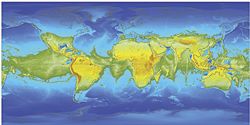
          If the Earth stopped we would have one big super continent around the middle of the Earth.  The forces created by spinning flattens the Earth at the poles giving the Earth a shape of an oblate spheroid (a difference of about thirteen miles).  More importantly the oceans which are deeper around the equator, possibly up to five miles deeper, would rush towards the poles leaving us with a land ring around the middle of the Earth.  I found the article here to be generally informative.  The information at the bottom of the page pointed to the creator of the map on an ESRI web site.  The ESRI web page has a very in-depth article on this thought provoking scenario.  The Earth not being a perfect sphere but an oblate spheroid made me think some more about mapping and projections as well.


Hypothetical Earth Continents if the Earth Ceased to Spin


          Something that came to mind after reading this article is the threat dams and their water mass pose to the spinning nature of our planet.  In general you could think of it like getting the tires on your car balanced.  Stopping this much water (water having a mass of 8.35 lbs per gallon) can unbalance the usual spinning nature of the Earth.  A quick Google search on "dams earth rotation" brings up a lot of information pertaining to this.  I found this NY times article about the topic.  The largest dam in the world is in China called the Three Gorges Dam containing 22.15 billion cubic meters of water.  This dam is giving the Earths rotation a close look among concerned people.

Wednesday, December 8, 2010

PA Canal System

          While working on my railroads final project I came across an interesting map of Pennsylvania's canal systems.  The more I work on the final project I realize how historically close canals and railroads are.  The general consensus around 1810 was that canals were best way of transporting goods and secondly people.  Railroads started largely as feeders to canals and navigable water ways.  In 1812, John Stevens, who many consider the father of railroads published a pamphlet called "Documents Tending to Prove the Superior Advantages of Rail-Ways and Steam-Carriages over Canal Navigation".  This was a document publised in a time when there were no steam locomotives and also mentioned that railroads would be no more expensive than a turnpike (Pennsylvania Railroad Past and Present).


          The Juniata river, looking at this map was a major connector between Philadelphia and Pittsburgh.  To think earlier this summer I did a conoe trip on the Juniata from close to Altoona to a mid way point.  The outfitter is "Juniata River Adventures" they drop you off with a conoe and paddles and pick you up for a reasonable price.

Tuesday, December 7, 2010

WASS Did You Say

          Was going through my GPS and all the options some of which confuse me.  Anyway came across an option called WAAS/EGNOS and being inquisitive I wanted to know just what this was.  Garmin's web page gives a good summary of the technology.
         

           WASS stands for Wide Area Augmentation System and was originally developed by the Federal Aviation Administration and Department of Transportation to increase consistency of signal accuracy.  How it works.  There are 25 ground stations throughout the United States and 2 master stations on either coast that monitor GPS satellite data.  The master stations gather data from the reference stations and sends out a correction signal for GPS units that are WAAS enabled.  The corrected signal takes into account disturbances caused by the ionosphere, GPS satellite orbit and clock drift.  This technology is available only in the United States however there are other countries developing similar technologies.  Japanese Multi-Functional Satellite Augmentation System in Asia and Euro Geostationary Navigation Overlay Service (ERGNOS) in Europe.
          So what does this mean for my GPS adventures and just general increased accuracy if I desire it?  I'm not sure yet but the first chance I get I'm going to experiment with this.  I typically see on my GPS that I'm getting an accuracy indicator of + or - 9 feet and really never any better than this.  Garmins's web site says that I can get better than three meters (9.8 ft) accuracy.  I did find better numbers on other web sites I searched and a great explanation of what WAAS means to an average GPS owner here.  So if enabling WASS increases my accuracy by 2 or 3 feet when I need it that's neat.

Monday, December 6, 2010

Projections

          Well I've been working on understanding coordinate projections.  So any comments on my current understanding is welcome.  Okay, so I think of projected coordinates as two dimensional or a flat piece of paper.  Geographic projected coordinates as three dimensional or spherical and round.  UTM or Universal Transverse Mercator I find to be one of the more confusing geographic projections.  UTM however is the standard for all Federal Agencies so it's not going anywhere.  It's roots lie more in a earth based two dimensional system (Catesian coordinates) and deals more with horizontal representation and from my understanding neglects the earths poles.


          There are different datums for which all different projections of coordinates are based on.  The old datum model, the current datum model and similar datum models.  NAD 27 (North American Datum 1927) was created using the Ellipsoid Clarke model of 1866.   The center of NAD 27 is on Meades Ranch in Kansas.  NAD 83 which is more current and created using the earth centered model of Ellipsoid GRS80.  WGS 84 (World Geodetic System) aligns perfectly with NAD 83 both of these models were created using newer satellite technology and agree on the earth's spherical center point.  I think this is important because the earth is not a perfect sphere and surface altitude comes into play when considering surface location.  The older datum model NAD 27 when aligned with newer models is off by about 150 - 200 feet.  WGS 84 is most commonly used in our GPS units.